
I had planned on heading down to check out Shawangunk State Forest on Sunday, but as luck would have it a work emergency came up. My boss was kind enough to OK a personal day for Monday, and my wife was kind enough to take care of my familial responsibilities, so, off I went. It took a bit of luck to find the trail I was aiming for, a yellow-blazed connector to the Shawangunk Ridge Trail / Long Path (henceforth SRT and LP) off of NY 52 east out of Ellenville, NY. I actually pulled in to the parking lot I should have parked in: a small, uncompleted lot just up the road from the yellow trailhead, but I saw no markings whatsoever, and so I went back the way I had come. I pulled in to the first parking area I had seen, in a fancy brick-paved spot, and noticed a sign that read “30 minute parking” directly to the left of my window. In frustration, I drove a short way further up the road, to a larger turn-off, and parked there. As it turns out, this is the northernmost “P” in the Shawangunk State Forest, as shown on the SRT trail map provided by the NYNJTC. (I’ll cover parking in more detail at the end.)
Route 52 is narrow, windy, and trafficked enough that I was uncomfortable walking along it. The frequent tractor-trailers, gunning hard to navigate the steep terrain, didn’t help. Anyway, I made my way east from the turn-off, and noticed, as I was walking, that there was a little bit more room to the side of the road - this was the next “P” on the SRT trail map. Things were lining up. I kept scanning the opposite side of the road, and finally, just past the end of a guard rail, I found what I was looking for: yellow blazes, and, even better, blazes that indicate direction.
Into the woods I went.
The yellow trail is very, very lightly used; most of it was covered in moss or wet leaves, or, on a few occasions, impossible to find at all. I simply had to follow the blazes because there was no indication, whatsoever, of human traffic. I ran as much as I could, given the slick footing, and eventually came out onto a woods road. “Great!” I thought, “Here’s the SRT.” Sadly, it was not. The road I crossed isn’t even on the map, and it’s very overgrown. I continued on the yellow trail some more, crossed a beautiful, fast moving stream, and started heading back up hill. Eventually I came to a small, confusing clearing, with no trail running through it. The blazes led me across the clearing, though, and onto another woods road. Across the road were two blazes, for the LP and the SRT.
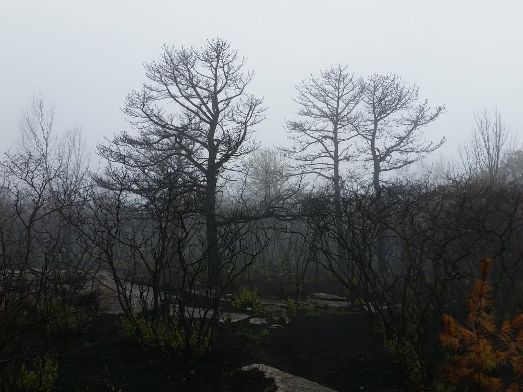
The smell of a campfire was prevalent here, and as I made my way up the LP, I started seeing the first signs of the forest fire. A piece of burned log here, several singed sassafras leaves there. I rounded a bend, and there it was: burnt earth, burnt trees, and a green path wandering through it. I ran some, but mostly I just stopped and stared. Overhead, a crow was screaming at me and circling. Clearly it was time to push on.
Eventually I came to a high place, where the bedrock was exposed in that gorgeous, slanted, Shawangunk style. Here, though, the rock wasn’t as polished as the rock found in Minnewaska and Mohonk, possibly due to some quirk of the glaciers. The rough surface should have been easier to grip with my shoes, but I found myself slipping all over the place, like it was ice. My best guess is that there was some oil left on them from the plants burned during the fire, either on the rock itself, or on my shoes.
I ran on for a little ways, found what appeared to be the high point of the ridge in this section, and stopped for a few more minutes to take it all in. Even the rock was blackened in places, and the ground underfoot was mostly charcoal. It was a surreal experience. The smell was overwhelming, like sticking your face in yesterday’s campfire. It reminded me very much of Lapsang Souchong, a smoked Chinese tea.
Despite the death all around me, there were already signs of renewal. The ferns that Kenneth Posner wrote about on May 26th were already two feet tall. I saw a lichen poking up from a burned dwarf pine. There were no animals, though, aside from the crow, and several piles of scat from what looked like a small-medium carnivore. It didn’t look like the scat had been burned.
After taking it all in, I started making my way back down to my car. When I got back to the second road, I decided to follow it instead of going back on the yellow connector trail. The stream crossing earlier had been sketchy enough that I didn’t want to repeat it if I didn’t have to. As it turns out, the woods road was an excellent choice. It lead me right back up to the parking area I had originally chosen; the woods road had been blocked from my view by a small piece of machinery.
I walked back down Route 52 to my car, and then headed over to Minnewaska to get in the rest of my run. At the fire site, I had actually climbed out of the clouds near the top of the ridge, but in Minnewaska, I was completely in the clouds, the entire time. I ran over to Lake Awosting on the Upper Awosting Carriageway, which was completely socked in from the cliff overlook. I tooled around a little bit on the slabs nearby, confirmed that there had been some kind of oil on the rocks at the fire site, and then headed back.
On the way back, not far from Lake Minnewaska, I saw a very large bird walk out onto the carriageway. It looked like an emu, and I couldn’t make out a wattle or fan to tell me it was a turkey. I froze, watching it for a minute, and then started to walk on. The bird quickly darted back into the woods, denying me the chance to ID it. Afterwards, it occurred to me that the mist could have been giving me a false sense of proportion, and it might not have been that large after all.
Anyway, that’s enough for today. Be excellent to each other, and below you’ll find some most excellent directions to the burn site.
Directions to the Shawangunk State Forest Parking Area (from the north): Take exit 19 off of the Thruway, and then follow US 209 south to Ellenville. In the village, turn left on to NY 52 east. Once you’re out of the village, you quickly find yourself on a winding mountain road. You’ll see a fancy scenic viewing area, and then a wider turn-off. If you have a vehicle with good clearance (my Outback did OK), there’s an unfinished parking area a short ways up the road. (At least it looks like it’s an unfinished parking area; there’s a ton of crushed stone and a machine for rolling it out.)
If you don’t have a vehicle with good clearance, you’ll probably want to park at the turn-off immediately after the fancy one. It’s big and wide. From there, you can walk up NY 52 and take either the yellow trail, or walk up to the unfinished parking area.
From the unfinished parking area, head down the woods road until you see the LP / SRT markers. Go left. If you look closely, you can see and smell the fire from here.
From the yellow connector trail, just follow it until you hit the second woods road, then cross the road and follow the LP / SRT. Note that the stream crossing on the yellow trail is treacherous in high water.
This was originally posted on my Ghost blog.