
Monday: The first of the Camp Saratoga 5K series, run by the Saratoga Stryders. I didn’t feel like I had a ton of push today, so I aimed my HR around 150, and then on the final kilometer I started cutting loose and passing people.
Wednesday: My family had intended on heading up to Heart Lake today, but a medical emergency dictated otherwise. I did manage to get out for a run tonight, and I heard a ton of night calls, including a bullfrog. I can’t recall the last time I heard one, but it struck me now how much like a bull they actually sound.
Thursday: We finally made it to Heart Lake. The kids enjoyed playing in the water and observing the wildlife; we kept it low key otherwise.
Friday: I woke early, and had a brisk walk around the camp while the others were asleep. My oldest was awake, too, and she started to join me, but she was too cold, and I walked her back to the site before continuing on. I pushed on past the lean-tos, and was rewarded with a ski slope with the far end gleaming in the morning light. Heart Lake was equally picturesque.
Sunday: Went for a run at Moreau Lake. I went via the southern entrance again, and decided to go check out Lake Ann. Not far past the lean-to I came across a downed sign warning of an active firing range, and a propped up sign warning about trespassing on the correction facility’s land. The trail definitely continued on, though, and there were clear markers; still, I felt uneasy enough to wait for another day. I remembered something about a local group building a trail in the area, and I thought it was one at or around Lake Bonita, but I couldn’t recall the specifics. I loaded up the Moreau Lake State Park map within PDF Maps, and saw that I was at the end of the trail, and beyond the park boundaries, as far as that map was concerned. In the end I decided to wait for another day before proceeding past those signs.
A bit of light research this evening shows that the trail does indeed continue on. A post on the SMBA page, the one I thought I had remembered, talks about building a trail between Lake Ann and Lake Bonita. Another recent post, this one on the Friends of Moreau Lake page, mentioned specific rules for visiting Lake Bonita, including a mention that the NYS Department of Corrections still runs a firing range somewhere in the area. So, no wandering off trail around Lake Bonita.
Back to the run; I turned around, and paused to explore a side trail across from the lean-to I had seen. It was clearly in disrepair, but it appeared to have been a series of bridges at one point, or possibly corduroy, but the spacing of the logs looked more like bridge footing, and there were a few logs still running with the trail: the former surface of the bridge. Lake Ann itself was more like a pond, and quite tranquil, but the ground just beyond the former bridges looked like it would swallow my calves whole, so I opted not to test it out.
I headed back to the junction, singing whatever could come to mind, mostly Megadeth, and a marching cadence version of The Raven. I had seen only one other hiker that day, and I really didn’t feel like running in to a bear right then. Part of the trail traversed through wetlands, at the head or tail of Lake Ann, and it was hard to see if there was anything that might attract a bear to come graze for a while. At the junction, I wavered between just heading home, and getting in a decent view. I chose the view, and headed to the Western Ridge Trail via the White Birch Trail.
(Those of you who are familiar with these trails will note that I could have just turned left on the Eastern Ridge Trail and picked up the Western Ridge Trail and an excellent view quite simply. But the woods were lovely…)
When I arrived at the junction with the Western Ridge Trail, I turned right, just to try and find the next overlook marked on the map. I thought it was right there, at the junction, but I was wrong. My watch said it was time to start heading back, so I texted my wife with an ETA, and started running the other way on the Western Ridge. I had forgotten how much uphill there was in this spot, and how easy it was to lose the trail here. At one point I found myself on an unmarked herd path. I knew approximately where the trail was, and PDF Maps confirmed it, so I just continued on the herd path and picked up the trail again. Unfortunately, I had completely skipped over the view!
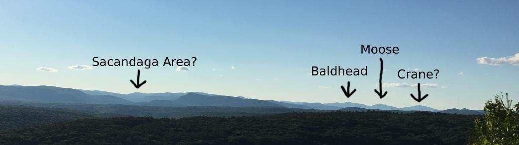
I quickly headed over to the view, and was amazed to see a tent pitched not far from the edge of the cliff. It didn’t look remotely comfortable: the tent was listing toward the cliff at a horrid angle and it appeared to be sitting on bare rock. If it was occupied, the occupants were silent. I took in the view, admiring both the Hudson up close, and the mountains on the horizon. It was difficult to identify peaks, but there were many to be seen. One, on the far left, looked perfect, and I wondered if it wasn’t Blue Mountain. Looking at a map now, I can see that’s impossible. According to PeakFinder, another handy app, it was most likely Crane Mountain, but I’ll need to bring binoculars next time to confirm it. In addition to getting a list of mountains currently around you, PeakFinder also allows you to enter coordinates and look at mountains as if you were standing there. Using that, I was able to pick out another mountain I had climbed, Spruce Mountain in Corinth. When you zoom in on the picture, a tower is clearly visible.
One final note: I was testing out a new backpack on this run. The Osprey Rev 18 has been added to my growing aviary, thanks to clearance at REI and a need to be able to hold more than the tiny amount that my Rev 1.5 holds. Don’t get me wrong: for long runs on hot days in civilization, the Rev 1.5 does the job perfectly. I just wanted to be able to carry more than a couple of small snacks on longer runs away from civilization. Today it performed very well, and I’ll be testing it out again soon.
Well, that’s enough rambling for now. Until next time…
This was originally posted on my Ghost blog.